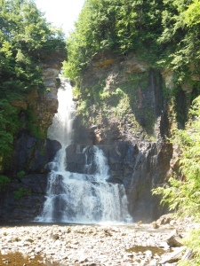
I never realized how close to my folk’s place a beautiful set of waterfalls existed! On July 16th of my upstate New York vacation, my stepmother and I visited High Falls Park, where the High Falls on Chateaugay River roars. It’s 120 feet high, and is defined as a “ribbon falls,” which means a waterfall whose height is notably higher than the crest width. I.e. (let’s get mathematical here), the height divided by 2 is equal or greater than the crest width. Note that there is no international standard in defining waterfalls, but the definition I took was developed by members of the Western New York Waterfall Survey of 1994, which is based on visual appearances. I found this definition in the book, Waterfalls of New York State, published by Firefly Books, which is a beautiful book!

To get here, first you have to be in up-upstate New York. Then you drive to High Falls Park (click here for directions), go inside the camp store, pay your $2 (yes, it’s just $2 for adults, $1 for students and seniors), and proceed through the building and out into the back, where the trail begins. The trial is open 9:30 a.m. to 7 p.m., summer hours. The park is open May 1st through October 15th.
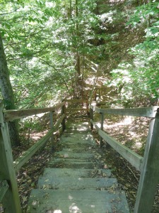
The trail is a well-maintained dirt path, where the last 350 feet is, well, um, near straight down over 200 wooden (and some stone) steps through thick New York vegetation. It’s quite the cool hike, as my pictures show!
The Chateaugay River is one of the smaller, and most northerly rivers in upstate NY. Its source is just a few miles upstream, in Clinton County, but the Waterfalls of New York State says the river officially begins in Franklin Country, where the waterfall resides. The river heads north after the falls and enters Quebec, where it is known as the Rivière Châteauguay. I love that name: “Chât-eau-guay“! This waterfall is the closest NYS waterfall to Canada.

My stepmom and I made our way down the 200+ steps and came out at the base of the falls, which was a rocky shore that also boasted a park bench atop one of its boulders. Out in the water of the falls (and visible in some of the pictures) was a guy fishing. As I explored the shore, I found tons of minnows in the shallows (I know “minnow” refers to a specific fish type…but I saw tons of “small fish” in the water, is my point). We spent some time there enjoying the view.
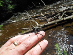
On the way out, one could proceed back up the steps, but my stepmom said there was another trail that looped back, and most likely wasn’t as steep. She’d been here before, years ago, and didn’t remember those steps we came down on…but did remember the trail we took back, which was more level—except for the last so-many yards. We did have to return to the top of the chasm! On our way there, along the Chateaugay, a dragonfly lit upon my hand. How cool! I love dragonflies!
If your knees and legs are up to it, this is a great short hike to see some spectacular North Country waterfalls! For such a stunning view, you just can’t go wrong at $2 a head!
Related Articles
- Donnelly’s Corners 2015 (fpdorchak.wordpress.com)
- A Trip Through Time (fpdorchak.wordpress.com)
Very nice, Frank. I really like the pics. Upstate NY (where, I should note, Rod Serling was from) is such a beautiful place.
Aye, that it is–on both counts!–and thanks!
There’s no standard in categorizing water falls… no double falls? width? Distance? What they pour into? What type of water origination? Nothing? How weird. I would have thought there would have been an entire subfield of geology devoted to waterfalls.. a basis for a book.. . hmmmm.
There you go, Inky! ;-]
Frank,
I started fishing the Chateaugay River in 1970. When I first came across high falls there was a brick pulp mill that sat next to the falls. The mill was no longer in use and was falling down. I had to hang on to trees and roots to descend from the bridge to the bottom of the chasm. The mosquitoes ate me alive. Another route was at the other end of the chasm where an abandoned railroad blocked the river (a very large stone culvert ran under the RR embankment). From there (to get to the chasm proper) you had to walk a VERY narrow ledge. If you fell – – – it was a permanent adios to this world. There is another Chateagay Chasm north of the Rt. 11 bridge that crosses the river. This one is fishable if you don’t mind hanging on to roots and branches while trying to cast. It is a wonderful place to visit. I could never get from one end of this chasm from the other due to its steep walls on one side and deep water on the other.
Thanks for listening.
Wally
Here are some recent posts I did on the North Woods area
https://waldotomosky.wordpress.com/2016/07/14/owls-head-1865/
https://waldotomosky.wordpress.com/2016/06/28/glenwood-stoves-in-chateaugay/
https://waldotomosky.wordpress.com/2016/06/27/all-aboard-for-malone-whippleville-chasm-falls-owls-head-and-mountain-view/
https://waldotomosky.wordpress.com/2016/06/26/old-days-in-chateaugay/
https://waldotomosky.wordpress.com/2016/06/23/adirondack-images-and-tales-the-percy-bridge-2/
https://waldotomosky.wordpress.com/2016/06/22/three-bridges-same-location-different-eras/
Cool! Will take a read! And I’ll have to look into that other chasm next trip out there!